1/3


Fly3D
1K+Downloads
7.5MBSize
2.84(11-01-2023)Latest version
DetailsReviewsVersionsInfo
1/3

Description of Fly3D
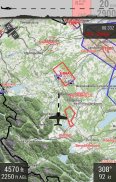
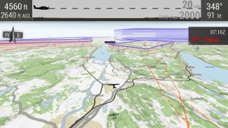
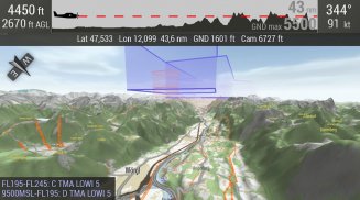
The first full 3D moving map for VFR pilots:
Flowing 2D and 3D representation of
* Landscapes
* Airspaces
* Routes (planning intuitively with elevation and 3D-window display)
* Tracks (gpx format)
* Aerodromes, traffic patterns (currently about 350 square rounds in Germany)
date maps for D / A / CH
Extensions for other countries + more features in the works ..
The app needs access to Fly3D infrastructure. Details on http://fly3d-app.com
Fly3D - APK Information
APK Version: 2.84Package: flocke.fly3dName: Fly3DSize: 7.5 MBDownloads: 2Version : 2.84Release Date: 2024-06-06 04:50:45Min Screen: SMALLSupported CPU:
Package ID: flocke.fly3dSHA1 Signature: EB:CE:DC:25:76:31:24:89:F3:E2:C9:C0:6C:88:9B:EE:58:9F:C1:4FDeveloper (CN): Florian MuellerOrganization (O): Local (L): Country (C): State/City (ST): Package ID: flocke.fly3dSHA1 Signature: EB:CE:DC:25:76:31:24:89:F3:E2:C9:C0:6C:88:9B:EE:58:9F:C1:4FDeveloper (CN): Florian MuellerOrganization (O): Local (L): Country (C): State/City (ST):
Latest Version of Fly3D
2.84
11/1/20232 downloads7 MB Size
Other versions
2.80
12/8/20202 downloads7.5 MB Size


